Thrilled to announce that our student Matthew Samuel successfully defended his Master Thesis «Characterizing the Value of Data in Kriging-Based Coverage Prediction«. His work integrated principles of data economics into spatial interpolation for mobile network coverage prediction to understand what are the features of data that make it more or less valuable to estimate reference signal received power (RSRP), a key indicator of good or bad prediction.
Mobile coverage prediction is essential for network planning and optimization. This is usually done by using limited observations based on traditional drive tests or crowdsourced measurements. Therefore, the challenge is estimating coverage in areas where no observations are registered, and hence this value must be guessed based on the existing information.
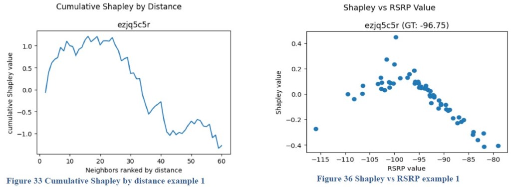
To address these challenges, the study extends a value-based data valuation framework by incorporating Kriging with uncertainty and applying Shapley values to quantify the marginal contribution of average observations registered in a geohash and even individual data points, in several scenarios built out of a dataset of 197,018 measurements across 3,867 geohashes in central Madrid as input data provided by WePlan Analytics.
Kriging is a geostatistical interpolation technique used to estimate values at unsampled locations based on known values at nearby locations, while also providing an estimate of the uncertainty associated with those predictions. It’s a powerful tool in spatial analysis, particularly when dealing with data that exhibits spatial correlation.
Shapley value exact estimation is considered intractable, but we resort to
truncated structured sampling approximations and parallel computing to approximate Shapley values even at individual observation level. We leverage PIMCITY value-based data valuation framework library to make these calculations.

Figure. Value of individual data points in estimating RSRP
Results demonstrate that individual observations yield higher Shapley values when collected close to the prediction target and when the measured RSRP closely matches the ground-truth level of the target. This finding points to removing outliers and reducing the radius of observations taken into account in the estimation as potential techniques to save processing in interpolating spatial observations to estimate mobile coverage.
Matthew obtained a 9/10. Congrats!

Deja un comentario